Tuesday, 25 September 2012

Confusion at Ferryhill (NZ290328)


No one can say for sure how the town of Ferryhill in County Durham got its name. There are three theories. The first speculates that the ford across the now extinct river to the east (where the railway line now runs) combined with the lofty position of the settlement gave the place its name.

The second proposes that it is named after Sir Roger De Ferry (or Ferie), who famously killed the last boar of Brancepeth at Cleves Cross – now a part of the town – hence ‘Ferry’s Hill’. And the third theory simply suggests that the name is derived from the Old English fiergen, or firgen, meaning ‘wood’, or ‘wooded hill’ – with the ‘hill’ suffix added later.

The name first appears in the records as ‘Ferie’ in 1125, ‘Feregenne’ in 1256 and ‘Ferye on the Hill’ in 1316 – and it appears as an unnamed settlement in an Anglo-Saxon charter of 900. It would therefore seem likely that the latter place-name theory is correct. It has also been suggested that the ‘hill’ element was added to differentiate the village/parish from Ferrybridge in West Yorkshire – once also known as ‘Ferie’ and also on the Great North Road.

Tuesday, 18 September 2012

Bishop Middleham Castle (NZ327310)


As you can no doubt guess from the settlement’s place-name, Bishop Middleham, a little to the north-west of Sedgefield in Co.Durham, was once the site of the Bishop of Durham’s residence. Though you wouldn’t know it if you went poking around the village today.

It is, however, likely that it existed as simply ‘Middleham’ in the 9th and 10th centuries, as the first recorded mention is in a 1146 grant of the local church to the Prior of Durham – and thus giving the settlement its full name. By the time of the Boldon Book in 1183, there were 32 households collected around the little church – and it seems the Bishop clearly had a residence there for a good couple of hundred years during 12th-14th centuries. Furthermore, it must have been well-favoured, as two of the said officials died there.

The Bishop’s manor house – for that is what it most likely was, rather than a ‘castle’ – would have enjoyed a lofty setting, high on the promontory which extends to the south of the present-day village and church. All substantial traces of masonry have long since disappeared, though examinations of the existing earthworks suggest the former presence of a strong and well-guarded affair. There is no documentary evidence to suggest that any high status structure survived in use beyond 1600 – and indeed the remains are so scanty that they have even been omitted from some editions of the OS maps over the years.

Here’s how it looked in 2007…

© Copyright OliverDixon and licensed for reuse under this Creative CommonsLicence.

But a nice artist’s impression of it in its heyday can be seen here (church is to the left).


Tuesday, 11 September 2012

Durham County Lunatic Asylum (NZ355305)


About one mile due north of central Sedgefield lies the site of the former lunatic asylum for County Durham, latterly known as Winterton Hospital. Virtually none of it remains today, which is probably just as well given the murky history of these questionable institutions.

The name ‘Winterton’ came from the former mill which occupied the site prior to the construction of the purpose built asylum in the late 1850s. Designed by John Howison, it was originally a 300-bed affair spread over three floors, with male wards to the west and female wards to the east. It was Elizabethan in style, mainly red-brick in construction, and came with so many extras that it was self-sufficient for much of its lifespan (including its own water supply, farm, fire service and cricket team).

It was more than doubled in size during 1875-80 – including the building of a new chapel (St.Luke’s) to hold all 700 inmates. More improvements and additions were made in the early 1930s, with the number of patients peaking at around 2,000 in 1954 – by which time it had effectively merged with the growing Sedgefield General Hospital under the auspices of the NHS. Additions continued to be made through the 1960s and ‘70s, with the institution carrying on in one shape or another until its eventual closure in 1996.

Almost all of the asylum buildings have been demolished (a new housing estate and other new buildings occupy much of the site), though a few lodges, etc – and the chapel – remain. Intriguingly, during demolition previously forgotten basement tunnels and rooms were discovered containing preserved specimens taken from patients decades previously.

More detailed information (and some great pictures) here.

Tuesday, 4 September 2012

The Birth & Rebirth of Hardwick Park (NZ344290)


Gothic Ruin Folly, Hardwick Park

A visit to the modern-day Hardwick Park, near Sedgefield, at the height of summer can scarcely be bettered as a family day out in the North-East of England. A leisurely perambulation of the Historical Circuit Walk is just the ticket to wile away a couple of lazy hours.

Though the creation we see today is the result of the labours of the Hardwick Park Restoration Project of the early 21st century, the venue’s reputation as a pleasure ground goes back to at least the 1740s. For it was at this time that wealthy Tyneside businessman, John Burdon, set about transforming the estate – if only for the enjoyment of himself and that of his friends and acquaintances.

Burdon, with the help of leading architect James Paine, built the new (and present) Hardwick Hall, and grandly revamped the grounds in a ‘naturalistic’ way. Yes, there were follies and other ornamental buildings, but the artificial lake was improved and a serpentine river added – all tastefully supplemented by judiciously placed woodland. A later owner, Matthew Russell, added a number of improvements around 1800.

Within decades, though, the park lurched into decline – a process which lasted the best part of two centuries, before local efforts led to its sensational re-birth during the last decade or so. Thanks to a generous Heritage Lottery Grant, the local council were able to spearhead the project which returned the landscape to its 18th century look.

Now, of course, the vast expanse of parkland with its many and varied points of interest is open to the public, and comes complete with visitor centre and all mod-cons. The hall, on the other hand, is a luxury hotel.   


Tuesday, 28 August 2012

Cosin-work at Sedgefield (NZ357288)


John Cosin was one of Durham’s most famous prince-bishops. He ‘ruled’ for a little over eleven years from December 1660, and was generally held in good regard for his work both within and without the Church – including promoting the interests of schools and charities.

Arguably his most famous legacy, however, is the unique style of church woodwork he championed – an elaborate and intricate cross between Gothic and Jacobean. Little of this remains today, however – the font cover in Durham Cathedral being the best example. Further fine examples of Cosin-work were tragically destroyed by fire at Brancepeth in 1998, leaving those remaining at St.Edmund’s Church, Sedgefield, as perhaps the best we have left of this distinctive style of craftsmanship.

Surprisingly, there are no good images to be had of St.Edmund’s beautiful interior décor on the Internet*. You’ll just have to go and see it for yourself, I guess.


* If you know of any let me know.

Tuesday, 21 August 2012

The Changing Landscape (NZ310260 & thereabouts)


Modern drainage techniques of the past couple of hundred years or so have transformed our landscape. Gone are the large tracts of uninhabited and largely useless areas of our countryside formerly given over to fenland and marshes. And although the North-East region is hillier than most, we still have many examples of this in our part of the world.

If you spend a lot of time studying maps you will be familiar with the term ‘carr’, which means a wooded fen in a waterlogged terrain. Essentially, a low-lying, soggy area, zigzagged by watercourses and peppered with trees such as alder and willow. Soon enough, of course, these areas are drained by man, dry out and are cleared to create farmland.

But often the ‘carr’ place-name element remains. And so it is with the four or five square miles of open expanse that lies between Newton Aycliffe and Sedgefield in County Durham. Look at the map today and you will find such name as Bradbury Carrs, Morden Carrs, Carrsides, Ricknall Carrs, Preston Carrs and Swan Carr Farm. The area is noticeably devoid of contour lines, though not short of meandering waterways.

Then there are the high points: Great Isle, Little Isle, High Farm and Morden (‘the hill in the fens’). There is Rushyford and Rushyford Beck – self-explanatory, I think. Look at an old map and you’ll see more telling evidence still: the area itself being known as ‘Bradbury & The Isle’, with a clearly labelled feature called ‘The Lough’ (the lake) sitting a little to the south of Morden. And I’ve probably missed some other references, too.

Now there’s nothing left of the former, sodden landscape except for two neatly channelled rivers, the odd sizeable puddle after a downpour … and, of course, the place-names.


Tuesday, 14 August 2012

Wellington’s Altered Obelisk (NZ424254)


© Copyright OliverDixon and licensed for reuse 

The famous Duke of Wellington was a regular visitor to the 3rd Marquess of Londonderry’s Wynyard Hall. They’d been companions-in-arms during many a military skirmish overseas during their younger days, and after the construction of the latter’s magnificent new pile in the 1820s the duke regular popped in for a cuppa and a chat.

In 1827, the marquess was so overcome by his friendship with the great man during one particular visit that he threw up a 127ft obelisk in his honour in the grounds of Wynyard.  Not only that, but the family wing of the mansion itself was nicknamed the Duke’s Wing – and this side of the house also held the Duke's Gallery, where the family kept their art collection.

As for the mighty obelisk, illustrated above, the inscription once read:

WELLINGTON, FRIEND OF LONDONDERRY

However, when, a few months later, Londonderry was not given a place in prime minister Wellington’s cabinet, the message was altered to, simply …

WELLINGTON


Tuesday, 7 August 2012

Wynyard: the Best in the Land (NZ421257)


Wynyard Hall, c.1880

The Wynyard Hall/Park Estate, a few miles north of Stockton-on-Tees, has long been a beauty spot. Though the current magnificent mansion dates from a two-pronged building programme spanning 1822-41 and 1842-46 (divided by a catastrophic fire), its history – and reputation – as a site of splendour goes back many centuries.

In the mid-1600s, for example, it was described as fruitfull of soile and pleasant of situation, and so beautified and adorned with woods and groves as noe land in that part of the country is comparable unto them. In the ensuing two centuries, various avenues, terraces and gardens were added to enhance the landscape, until the Grecian mansion was added as per above. It was the 3rd Marquess of Londonderry who was responsible for the construction of the present edifice – the famous coal magnate himself – and it was at the brand new hall that, in 1847, a lavish birthday bash was laid on:


Amongst the distinguished company present was Prince Louis Napoleon, afterwards Emperor of France. On this occasion there was a curious card party, which deserves to be made historical. The gentlemen who took a hand in it were Louis Napoleon, Benjamin Disraeli, George Hudson (the Railway King), and J.J.Wright of Sunderland.

Disraeli, in fact, loved the place. On leaving London for a trip to Wynyard he once said, “I never left London with such a sense of relief and such anticipation of happiness.” More recently, Nikolaus Pevsner described the hall as “the most splendid 19th century mansion in the country.”

Royalty and the social elite have frequented the establishment, including visits in the Victorian era by Edward Prince of Wales and later by Queen Elizabeth II. 


In celebration of the 2012 Olympics, GenesReunited are currently offering 20.12% off their Platinum subscription (offer runs until midnight on Sunday 12th August). Click below and jump to the 'subscribe' section.

ancestor, ancestry, family tree, family history, r


Friday, 3 August 2012

Elsdon & its Pele, Redesdale (NY936933)


Guest Post by Tom Moss


Elsdon in Redesdale, Northumberland, has a timeless air with many reminders of a bygone age. For all its turbulent history, it is a delight to the eye: picturesque with a rolling village green and a delightful array of stone houses. Here are to be found the Mote Hills which once housed the Motte and Bailey castle of the Umfravilles, Lords of Redesdale. They came with the Conqueror, William of Normandy, and were granted the lands of Redesdale to hold it against his enemies and wolves. The long-gone castle was built in the year 1080 and served as the headquarters of the Umfravilles until about 1157.

Elsdon Pele is a magnificent example of the fortified towers built on each side of the English-Scottish Border as both defence and sanctuary against the Border Reivers. It was built about the year 1400 for the Umfravilles but by 1415 it was in the hands of the Rector. His original home had suffered at the hands of Scottish Raiders. Not long before, in 1399, a Truce between the Scots and English had ended and the North of England was very soon afterwards plundered by the Scots. Elsdon was often a target. There is documentary evidence that the tower was standing in 1415 and that it belonged to the Rector – 'Turris de Ellysden' belongs to 'Rector eiusdem'.

It still preserves its character today even after many additions and renovations. The walls are massive and the original vaulted ground floor was once the pen of horses and cattle during Scottish raids or a place of refuge from feuding neighbours. The pele tower is a truly wondrous sight and dominates the village.

Although the tower of Elsdon was strong and fortified and offered shelter for the villagers in the endless raids from the Scots, there were many times when the people suffered at the hands of the infamous Border Reivers. An attack of particular note took place in September 1584 when Martin Elliot and five hundred men from Liddesdale attacked the village. Such great numbers indicate that the Scots came in reprisal for earlier raids against themselves. As the Scottish Border Reivers turned for home they left fourteen men dead, had burned down all the houses and made away with four hundred kye (cows), oxen and horses, insight (household goods), and taken four hundred prisoners.

From the records that still exist from the time it is clear that the raiding and reiving had reached an intensity that had existed for at least a hundred years before the Liddesdale raid. In 1498, the Bishop of Durham had threatened excommunication on the reivers of Tynedale and Redesdale (which included Elsdon) – not for attacks on the Scots, which was presumably acceptable, but for the family feuds which had reached such an intensity that God-fearing folk lived in daily terror of a raid from their own countrymen. The reiving was literally relentless – and the remedy hard to come by!

Today a visit to Elsdon is a great pleasure. It is a peaceful place nestling in rolling hillsides – yet proud of its history and its turbulent past. The church, pele tower, village green and the Mote Hills are all much as they were five hundred years ago – but back then every man looked over his shoulder, wary of the next attack to come screaming out of the hills.


Tuesday, 31 July 2012

Orwell’s North-East Retreat (NZ390226)


A little to the north-west of Stockton lies the village of Carlton, and a few hundred yards to the north of that can be found Greystone Lodge. Astonishingly, this little corner of the North-East was once, briefly, the home of the great George Orwell during what was one of the most important periods of his life.

Already suffering from ill-health, the author and his wife, Eileen, moved there in 1944 together with their adopted son, Richard, following bomb damage to their London flat. The house belonged to his wife’s sister-in-law, Gwen.

It was here that Orwell put his finishing touches to Animal Farm, which was published in 1945 – and highly likely that work was commenced (at the very least in his head!) on Nineteen Eighty-Four (working title The Last Man), which itself was published in 1949.

The peace and quiet of Greystone must have seemed a world away from the horrors of the ongoing war, of which Orwell was desperate to be a part of (but was preclude from on health grounds). But it wasn’t to last. For when he was offered (and accepted) a post as war correspondent in France in 1945, his wife died in his absence on the operating table in Newcastle whilst undergoing a hysterectomy. He returned to Greystone to find her unfinished final letter home from her hospital bed lying on the hall table.

He remained for a few more days, attending to the funeral and his adopted son’s future, before severing his links with the North-East for good. He struggled on for a few more years through ailing health, until his own death in 1950 aged just 47.

P.S. Strange but true: Orwell’s real name was Eric Arthur Blair, and Greystone overlooks the parliamentary constituency of Sedgefield, Tony Blair’s old stamping ground.


Tuesday, 24 July 2012

Sir Anthony Carlisle (NZ364227)


Old Stillington – the original village, not the nineteenth century creation which jumps out at you from the map of today – lies a mile to the south-west of the modern affair on a quiet back road. Its simple layout has scarcely changed since the time of Anthony Carlisle’s birth there way back in 1768 – a young lad who would move onto the world stage during the course of his lifetime, yet is barely remembered today.

The son of Thomas Carlisle by his first wife (identity unknown), Anthony was apprenticed to medical practitioners in York and Durham, before completing his studies in London and being appointed Surgeon at Westminster Hospital in 1793. He remained there until his death in 1840.

But in the days when men of science dabbled in several disciplines, Carlisle’s mind often wandered. During one such ‘distraction’ he made the not insignificant discovery of the process of electrolysis with chemist William Nicholson in 1800 – this being the process of driving chemical reactions by passing electricity through a liquid substance*. In this case, it was the passing of a current through water, thus decomposing it into its basic elements of oxygen and hydrogen. Just as importantly (for him, at least) he got himself married in 1800, too, to one Martha Symmons.

Though he never followed through with his newly-created science, many others did to stunning effect. Carlisle’s contribution was acknowledged, though, when he was elected a Fellow of the Royal Society in 1804 (and served as Professor of Anatomy of the Society during 1808-1824).

From 1815 he began a long association with the (Royal) College of Surgeons, serving as president in 1828 and 1839. He lectured widely and prominently**, and was appointed Surgeon Extraordinary to King George IV(1820–1830) – and must therefore have known, quite intimately, the sufferings of the monarch’s father, ‘Mad’ King George III, prior to the man’s death in 1820.

Carlisle was knighted in 1821, and died, after a long and successful career, in London in 1840. He is buried in Kensal Green Cemetery.


* & ** Because of his association with electrochemistry, Carlisle has been labelled ‘The Real Mr Frankenstein’ (see here, and see also here – and scroll down), and his lectures were often especially graphic – and very popular! He may even be the author behind the 1797 gothic horror classic The Horrors of Oakendale Abbey, which tells of resurrected men and body-snatchers.


Tuesday, 17 July 2012

Great Stainton’s ‘Paved Road’ (NZ337220)


The village of Great Stainton is so named, one assumes, to distinguish it from lesser known – and smaller – places of the same name scattered around and about the Co.Durham settlement. There’s Little Stainton, Stainton Grange and Stainton Hill House – to name the few I can find on a modern-day map. It is also probably the ‘original’ Stainton, situated, as it is, directly upon the course of an old Roman road – the Great being added in the 17th century.

The thoroughfare (which no doubt pre-dates the Roman era) runs roughly north-south through the village along the course of the present-day metalled road. It was once known as ‘Stainton-in-the-Street’ or ‘Stainton-le-Street’, being reference to its situate – though, interestingly, the place-name experts would have us believe that the word ‘Stainton’ on its own actually means ‘farmstead by the paved road’ (from the Old English stanwegtun).

An early Roman coin from the reign of Emperor Vespasian (9-79AD) was found in the churchyard, indicating that the legions came this way at a very early point in their occupation of Britain. When the Anglo-Saxon settlers came along and started tagging names to their places, they came to this corner of the region, found a few houses sitting astride a nice cobbled road … and Stanwegtun was born.

Having said all this, the staggered (Roman) crossroads 200 yards north of Great Stainton was most probably the site of the first community. For here there are faint traces of the settlement shown on the early OS maps as ‘Cross Hill’.


Tuesday, 10 July 2012

Bishopton’s Castle Hill (NZ366209)


© Copyright HughMortimer and licensed for reuse 
under this Creative CommonsLicence.

The prominent set of earthworks known as Castle Hill, near Bishopton, a few miles west of Stockton, is one of the finest examples we have in the region of the classic Norman ‘motte and bailey’ design of fortification.

There is a 38ft high central, circular mound (or motte), surrounded by a ditch and earth bank. Around and about various earthworks may be found, providing clear evidence of a ‘bailey’, plus causeways and embankments (nice shot here). Nearby Bishopton Beck would have fed the moat, rendering the castle an island of sorts should the need ever arise.

Its origins are not known, but most probably lie in the early twelfth century. The site certainly seems to have been pressed into service during ‘The Anarchy’ of 1135-53, with Bishopton Castle being, possibly, the site chosen by Roger Conyers to defend himself against the Bishop of Durham when a dispute arose over the see. At its ‘peak’, it is likely that the fortification was little more than a timber fort – though with an elaborate outlying complex.

Local legend has it that the hill is haunted by fairies, and that every time someone tries to take soil from the site they are warned off by whispering voices. It hasn’t stopped some, though – as recently as the year 1800 the hill stood as high as 60ft, apparently.


Tuesday, 3 July 2012

Norton’s Quakers (NZ446221)


© Copyright Carol Rose and licensed for reuse under this Creative Commons Licence

The first Quaker Meeting House proper to be built in the settlement of Norton was on the site of the current affair in the year 1671. Much altered over the years, the present structure dates from 1903 when it was rebuilt in the style of the original building.

What is remarkable, though, is how the religious body itself has managed to survive at all. Whilst some sources refer to the town’s ‘comparatively peaceful history’, the Quakers have suffered anything but a quiet existence there. Born around the time of the English Civil War, the Quaker movement made enemies of both Roundhead and Royalist alike – though the former tolerated them due to Quaker sympathies among their foot soldiers.

On the Restoration in 1660, there was a severe clamp-down on the activities of the ‘obstinate men and women’ of the parish ‘who would not let down their conventicles’. King Charles II sent a party north to root out the Quakers – one Simon Townsend having his house taken (the site of the alleged activities of the dissenters). Townsend and several others were severely punished, with the period of oppression in and around the town continuing deep into the 1660s.

The record books are peppered with cases brought against the peace-loving ‘Society of Friends’ groups of this period. At the very height of the oppression, the Norton group built their first ‘official’ Meeting House on the village green in 1671. Massive fines, transportation and the like continued for those openly flouting the obligation to attend ‘national services’ in favour of their own religious gatherings, but the Quakers hung on until the ‘freer’ days following Charles II’s death in 1685. Though, in fact, an Act was passed against them as late as 1687 barring them from entry into many professions, they laid low thereafter, concentrating on social and industrial endeavours to stunning effect through the Industrial Revolution and beyond.

More information here.


Tuesday, 26 June 2012

Jeremiah Moore of Norton (c.NZ445220)


July 20th 1753, died, at his house at Norton, Jeremiah Moore, esq., aged 57. He was the last of his family; and had, in the former part of his life, suffered extreme hardships, through the cruelty of his older brother; by whose means he was carried into Turkish slavery; and at the time of his brother’s death, was a common seaman in the navy, having been pressed in the Mediterranean, after he had made his escape from the Turks. When he came to his estate, he converted it into money, and settled in the north, exercising acts of goodness to all his poor neighbours, to whom he left largely. Having no relations, he bequeathed to six gentlemen, who were kind to him in his adversity, £1500 a-piece; and to his housekeeper, Mrs Ann Kendal, his executrix and residuary legatee, £3000 in trust for her son. All the legatees were enjoined to receive their legacies at his house in Norton, over a large bowl of punch, on the first of March next after his death; and they were required yearly to commemorate that day as long as they lived, it being the day he escaped from slavery.

[From The History and Antiquities of the County Palatine of Durham, Volume 3, p.112, by William Hutchinson]


Tuesday, 19 June 2012

Will Hay of Stockton (c.NZ446193)


[from Wikipedia]

The great William Thomson “Will” Hay was a famed comic screen actor of 1930s and 40s Britain. As a child, he lived in several locations throughout England as his father sought work, but was actually born in Stockton-on-Tees to parents William and Elizabeth in December 1888.

Will began his adult life as an engineer in Salford, but decided to become an actor in his early 20s, spending many years as a music hall performer – including some time in Fred Karno’s famous comedy troupe. After a long and successful stage career, he broke into film in his mid-40s and spent a short but highly successful few years in the business (1934-1943), before moving (very briefly) into radio. His film portrayals saw him play bumbling authority-figure characters – among them lead roles in  Boys Will be Boys, Oh, Mr Porter!, The Ghost of St.Michael’s (above), and My Learned Friend.

He wrote much of his own material, and was also, interestingly, a highly-respected amateur astronomer (and a Fellow of the Royal Astronomical Society, no less). Furthermore, he was one of Britain’s first private pilots (he gave lessons to Amy Johnson) and spoke several languages proficiently. He was married – and fathered three children – before separating from his wife, Gladys. Sadly, he spent the last two years of his life disabled following a stroke in 1947.

Will Hay died in 1949, aged just 60, and was buried in London.


Important Notice

Henceforth I will only post to this blog ONCE per week - usually a Tuesday. Any guest posts by other folk will appear on Fridays (though no one has yet submitted any articles). If you wish to contribute - or for further details in general about this change in policy - see here.


Tuesday, 12 June 2012

Walker’s Friction Match (c.NZ445189)


One of Stockton-on-Tees’ greatest claims to fame is that it was the home of the man who invented the friction match, one John Walker. The chap in question was born and died in the town, spent most of his days there and, crucially, made his invention in his little chemist shop on the town’s High Street.

Matches weren’t a new idea. The Chinese had a version of them when the British were still in the Dark Ages, and many famous names had fiddled about with the concept in Europe way before Walker was born (including Robert Boyle). However, the self-igniting friction match was something new – and the North-East is most certainly the place where it first saw light of day (as it were).

Walker was born in 1781, and was supposed to have been a surgeon. Not liking the sight of blood, he instead switched his studies to chemistry, and eventually opened up his own place in his home town. He became obsessed with the idea of obtaining fire easily and began experimenting with various concoctions – until he hit upon a successful combination of chemicals and equipment in late 1826. There are various versions of the momentous event itself, but it seems that Walker noticed that a mixture of chemicals he had been working with had hardened on a mixing-stick – and when he tried to rub them off on the hearth, the thing ignited in his hand. And thus the friction match was born.

He didn’t seem to think much of the invention. From April 1827, he sold a few dozen packets of them (complete with a sandpaper sheath through which to draw the match-stick, and called ‘Congreves’ in honour of another inventor, one Sir William Congreve), but never got round to patenting the idea. Inevitably, others copied or came up with near identical ideas in time, and the fortune-making ended up elsewhere (notably Samuel Jones’ ‘Lucifers’ from 1829).

However, John Walker seems to have done sufficiently well out of his creation to enjoy a reasonably comfortable life up to his death in 1859, aged 78. He is buried in nearby Norton.


Important Notice

Henceforth I will only post to this blog ONCE per week - usually a Tuesday. Any guest posts by other folk will appear on Fridays (though no one has yet submitted any articles). If you wish to contribute - or for further details in general about this change in policy - see here.


Tuesday, 5 June 2012

Stockton’s Stocks (NZ445189)


[From The Monthly Chronicle of North Country Lore & Legend of April 1888]


‘Reminiscences of Stockton by W.Fallows

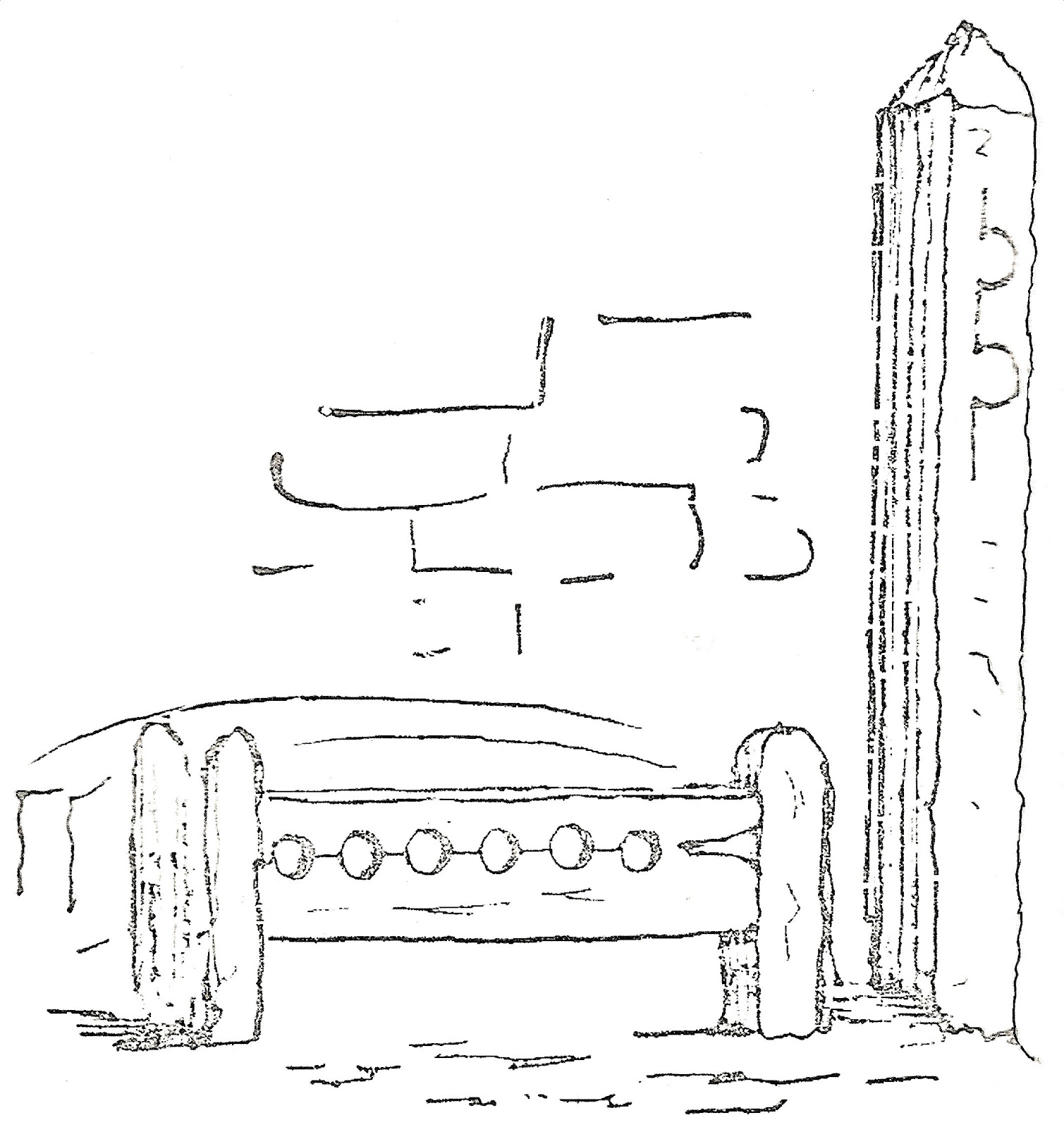
Some time ago, I was inquiring when the old ‘stocks’ were removed from Stockton, but no one knew anything about them. The punishment of setting people in the stocks was general in former times, being a frequent order by the justices in Quarter Sessions. We are told by the antiquaries that stocks were used in Anglo-Saxon times, and anyone who owns a copy of the ‘Records of the North Riding’ will learn their use at a very early period, with particulars, also, of the whipping-post, a punishment to which women, as well as men, were condemned. At a Quarter Sessions in 1651, the inhabitants of a parish near Easingwold were fined for not having a pair of stocks in their constablewick. I remember having seen men in those at Stockton, but do not remember seeing anyone whipped. The stocks and whipping-post were at the south-west corner of the Town Hall. I have made a drawing of both, which I remember well.


The market of that day was very thinly attended; the butter-sellers were all on the north side of the Cross, and the corn market at the north side of the shambles. There were a few stalls for the sale of different kinds of clothing and very small hooks; also carts with vegetables, &c. On the west side were all kinds of odds and ends. On one occasion a man got on to one of these stalls and called a public auction for the sale of his wife. The woman was sold for 2s 6d. The affair caused a great noise in the town.

The rage for improvement has cleared away another mark of an old pastime in Stockton. That was a flat stone about three feet square with a pin in the centre, to which in former days was attached a ring with a chain for holding a bull to be baited. This was near a public pump, and on the west side of what was called the Coal Hill, where carts with coals, for the supply of the town, usually stood for sale on the Wednesday and Saturdays.


Important Notice

From this week onwards I will only post to this blog ONCE per week - usually a Tuesday. Any guest posts by other folk will appear on Fridays (though no one has yet submitted any articles). If you wish to contribute - or for further details in general about this change in policy - see here.


Friday, 1 June 2012

Sadberge’s Long History (NZ340168)


The village of Sadberge, a little to the east of Darlington, has one of those ancient-sounding place-names that you just know has a long and interesting history. And it has, though a good deal of it has always lain tantalisingly out of the reach of a succession of local historians.

What is known for sure is that a Roman road, Rykenield Way or Street, ran directly through the place, north-south, and that because of the settlement’s elevation, they probably maintained a signal station of sorts on the spot. Perhaps they even built a camp or a fort there, but no one has been able to find definitive evidence. Rumours persist of a later ‘Saxon castle’ in the vicinity of St.Andrew’s Church – perhaps a stronghold of the Dark Age Kingdom of Deira.

Next it was the Vikings. And it was they who gave the village its name – Sadberge deriving from ‘Set-berg’, meaning ‘flat-topped hill’. It became, in fact, the focus of their local wapentake (administrative centre), covering large tracts of land to the North of the Tees. Its status stuck for centuries thereafter, and became known as the ‘Earldom of Sadberge’.

It was so special, in fact, that it was not initially taken into the domain of the Prince Bishops of Durham in the early days of Norman rule – but was eventually added in 1189. It remained ‘special’, however, and continued to be administered almost as a separate county until deep into the 16th century.


Today is the blog's 2nd anniversary! 
See here.


Tuesday, 29 May 2012

Teesside’s Sailing Coaches (NZ452183)


During 1845-6, ex-sailor, Joseph Taylor, struck upon the idea of using sails as a means of propulsion for railway carriages. 

Taylor ran a provisions shop in Middlesbrough near to the town’s first railway station.  In the absence of a Sunday rail service, he used to harness a horse to a railway carriage and haul his family to their place of worship – the Society of Friends Chapel – down the line to South Stockton (the northern end of the modern-day Thornaby), a distance of four miles. 

However, when the climatic conditions allowed, he was seen to dispose of the horse and affix a mast and lug sail to the carriage and glide gracefully into South Stockton at a brisk eight knots an hour.

[adapted from an article which appeared in The Monthly Chronicle of North-Country Lore & Legend of August 1891]


Remember, if you'd like to submit a short article for the 'North-East History Tour' then see the link at the top of the page. Anyone can do it!