Tuesday 30 December 2014

Hepburn Bastle (NU071249)


© Copyright Russel Wills and licensed for reuse 

You don’t have to meander through the history of Northumberland for very long before you stumble over the terms bastle, pele tower and fortified house. The raiding Scots and the fraught inter-family feuding saw to it that anyone who had anything worth stealing would do their best to keep out the wandering baddies with the construction of these stone-built strongholds.

Hepburn Bastle, though, is a curious affair. Situated at the southern end of Chillingham Park, it has defied accurate categorisation since its (probable) late 14th century creation. Described now as a ‘bastle’, it is more accurately a ‘fortified medieval tower house’. Though ‘tower’ is stretching it a bit, fortified it most certainly is. To complicate matters, buildings were added to it in the 16th and early 17th centuries – extensions which have since disappeared. Though it may have been built in the 1300s, it first appears in the records in 1509 as, simply, a ‘hold’, then pops up as a ‘tower’ in 1542, and by 1564 it is described as a ‘mansion house’.

Its dimensions are impressive. It measures 16.6m by 10.8m, is still three levels high despite being a ruin for an awfully long time and sports walls which are 2.7m thick at basement level. The ground floor comprises a barrel-vaulted basement with a later fireplace in the north wall – almost as if it was originally used (as in a bastle) to protect livestock, then later converted for human use – and at the east end a doorway leads to a mural chamber. The first floor has/had three rooms, each with a fireplace. The attic level, now minus its roof, has traces of fireplaces, windows and a window seat. Both the upper floors had their windows added after the Border region had quietened down somewhat – and were connected by a spiral staircase.

Though it is now known as Hepburn Bastle the original name was almost certainly Hebburn or Heburn – as is evidenced by its description in a 1715 survey as “a handsome house bellonging to Robert Heburn, esq.” (the ‘p’ was, we think, somewhat mysteriously introduced by the Ordnance Survey). The structure appears to have fallen from use around 250 years ago after the last Hebburn male heir died.


Tuesday 23 December 2014

Mysteries of the Hurl Stone (NU039247)


 © Copyright Russel Wills and licensed for reuse 

In the middle of a farmer’s field a couple of miles to the SW of Chillingham stands the Hurl Stone, a ten-foot high rough-hewn obelisk of unknown origin yet steeped in myth and legend. Hard facts are difficult to come by, but who needs ‘em?

First of all there is its name. Some speculate that it is derived from the ‘Earl’s Stone’ – though the identity of the gentleman in question is not known. It may have been an ancient standing stone (or cross) at one point, possibly relocated to its present spot by someone or other. Everyone’s  favourite theory, though, is that it was literally ‘hurled’ there by the Devil himself, who, when perched high upon the Cheviot, saw pesky St.Cuthbert going about his pious wanderings in the distance and threw the stone at him in anger.

The Hurl Stone is supposed to be the haunt of fairies, too. An underground passage some sixteen miles in length is supposed to pass under the stone (linking Cateran Hole in the east to Henhole in the west), which, when it was once explored in times of old, revealed evidence of underground fairy-like activity immediately beneath the stone. The adventurers didn’t hang around long enough to investigate further and scarpered sharp-ish.

Sorry to disappoint, but chances are that the Hurl Stone was once a medieval Christian cross which lost its top and was then recycled as a folly (of sorts) by someone with nothing better to do. Some attribute the act to a Mr Jobson, a local farmer, and that a bolt of lightning accounted for the missing couple of foot or so. 


Would you like to write a post for the 'North-East History Tour'? 
Click here for further details.
Don't be shy!

Tuesday 16 December 2014

Old Bewick & its Cup & Ring Marks (NU075215 & thereabouts)


© Copyright John Haddington and licensed for 

There is so much ancient history lying in the landscape among the western extremes of Bewick Moor that it is difficult to know where to start. So we’ll begin with the biggest feature: namely, Bewick Hill, which stands out like a sore thumb from pretty much any direction you care to view it from.

Traces of human activity go back more than 5,000 years in these parts; and Bewick Hill is the site of one of the area’s more recent features – an unusual hillfort known as Old Bewick, which dates from the Iron Age. It consists of two small, semi-circular enclosures sitting next to each other, with their open sides set against a cliff edge. A larger rampart then surrounds these enclosures, with traces of further embankments nearby. The western fort contains a collection of hut circles, with its partner holding some less well-defined stonework. The site may well have been occupied into the Roman period.


 © Copyright Andrew Curtis and licensed for 

A little to the east lie an important collection of ‘cup & ring’ rock art panels – one of which, Old Bewick 1a (pictured), is one of the best examples of its kind in the UK. These extraordinary relics of our past date (it is thought) from around 4,000 years ago, and it was here at Old Bewick that such carvings were first recognised as a man-made phenomenon. Despite extensive study, no one has been able to work out with any degree of certainty what they mean and why they were created, and similar examples are scattered all across this corner of Northumberland.

In between, chronologically, the formation of the cup & ring etchings and the later Iron Age hillfort, the Bronze Age burial cairn was laid down at nearby Blawearie, a little to the north. First discovered in the 19th century, it is a substantial affair containing at least four stone-lined burials, along with pottery, a flint knife and a jet and shale necklace. More investigations were carried out in the 1980s, all of which raised more questions than answers.

Other stuff lies close by. A second hillfort can be found a little further east, the odd Iron Age farmstead has been revealed by cropmarks and there is evidence of activity through the Roman period and into the Anglo-Saxon era. There are even a couple of World War II pill-boxes built into Bewick Hill – all of which adds a little extra depth and interest to the atmospheric landscape hereabouts.


Would you like to write a post for the 'North-East History Tour'? 
Click here for further details.
Don't be shy!


Tuesday 9 December 2014

Henry Ogle: Not to be Messed With (NU104195)


Eglingham Hall, like most buildings of its type, started small and has been added to considerably over the years. It began as a pele tower and today looks like this:

© Copyright Stephen Richards and licensed for 

When its development was somewhere in between, one Henry Ogle lived there for a time prior to his death in c.1669. He was a staunch Parliamentarian, and was at his most boisterous – nay, cocky – during the days of Cromwell. Around 1649-50 he was involved in two instances for which we have precious little information, but which nevertheless provide a neat little window into what was, at the time, a pretty crazy world.

The first occurred in the wake of the famous Newcastle Witch Trials of 1649. From Thomas Oliver’s A New Picture of Newcastle-upon-Tyne of 1831:

1649 – The Magistrates of Newcastle sent to Scotland for a man who pretended to discover who were witches: on his arrival the bellman went through the town, crying “all persons who would bring in any complaint against any woman for a witch, they should be sent for and tried by the person appointed.” Thirty women were brought into the town-hall, stripped there, and had pins thrust into their bodies, and most of them condemned for witches!

As a result, fourteen witches and one wizard were executed. The account continues…

The witch-finder went from Newcastle to Northumberland, when [magistrate] Henry Ogle, Esq. laid hold of him and required bond to answer at the sessions, he escaped into Scotland, where he was apprehended, cast into prison, and condemned; when on the scaffold he confessed that he had been the death of 220 women in England and Scotland, for the gain of 20 shillings each!

No one knows for sure who this notorious witch-finder was, but it may have been the infamous John Kincaid (however, Kincaid was not collared and executed until 1662, so there may be some confusion here).

Henry Ogle of Eglingham Hall may have played a prominent role in the casting out from the region of the pesky witch-hunters, but a year later he had a run-in with his ‘hero’ Oliver Cromwell, who, on the way to the Battle of Dunbar in 1650, stayed over at Henry’s house. Legend has it that the next morning the two of them quarrelled (over exactly what we don’t know), and that they may even have duelled over the disagreement.

I should think that their differences were soon patched up, though, as Henry was elected MP for the county in 1653 and 1654. But the story of the little dispute lived on, and inspired the poem Cromwell’s Visit: An Eglingham Legend by James Hall … and if anyone out there has the text of the said ditty I’d like to hear from them!


Would you like to write a post for the 'North-East History Tour'? 
Click here for further details.
Don't be shy!

Tuesday 2 December 2014

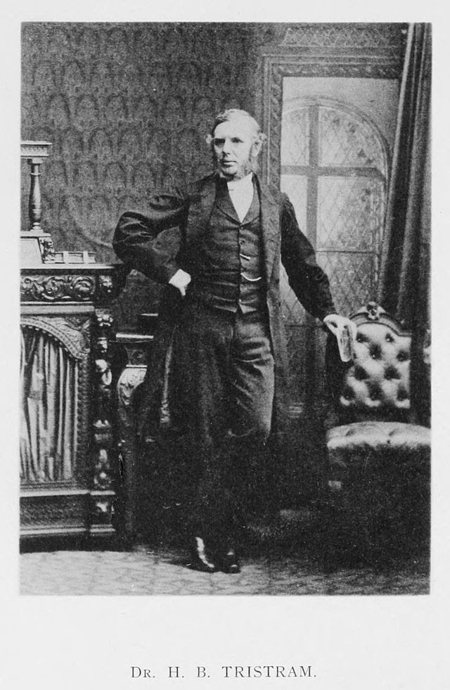
Eglingham’s Wandering Cleric (NU106195)


Canon Henry Baker Tristram was an English clergyman, naturalist, Biblical scholar and traveller. Somewhat controversially for his time, he was an early convert to Darwinism, and spent many years attempting to reconcile the theory with his religious beliefs.

Tristram was born at Eglingham vicarage in 1822 – the eldest son of the vicar – and studied at Oxford. He was ordained a priest in 1846, but his fragile health (TB included) forced him to live abroad. He travelled widely, including a stint as secretary to the governor of Bermuda from 1847 to 1849, where an interest in birds blossomed – but on returning to UK shores found the winters too much for him. Several expeditions to Algeria followed, including exploration of the Saraha desert and yet more ornithological adventures – and wrote a book entitled The Great Sahara. He first visited Palestine in 1858, returning there several times, where he expanded his collection of birds and identified possible Bible sites. Amidst all of this he became canon of Durham Cathedral in 1873, though his travels continued, including the Middle East and also Japan where his daughter spent decades working as a leading light at the Church Missionary Society’s School for Girls.

His infamous link with Darwinism began in the late 1850s when he was seduced by the writings of the great evolutionist. Looking at his own collections of birds, he became convinced of the validity of the new-fangled theory, and penned articles in support of the same.

Tristram, who was a Fellow of the Royal Society, wrote books, papers and articles of all his various adventures, concerned mainly with naturalism and the topography of the Bible lands. His sizeable collections of birds and eggs ended up in Liverpool’s World Museum and the Natural History Museum, London. And as any ornithologist will know, a number of birds are now named after him … as well as a breed of gerbil!

He died in 1906 and has a window dedicated to his memory in the north aisle of Eglingham Church.


Would you like to write a post for the 'North-East History Tour'? 
Click here for further details.
Don't be shy!

Tuesday 25 November 2014

Percy’s Cross & the Bird in Thy Bosom (NU053193 & thereabouts)


 © Copyright David Clark and licensed for reuse 

There are two monuments which go by the name of Percy’s Cross in Northumberland. One commemorates the Battle of Otterburn of 1388; the other – and the subject of this article – is situated about 4 miles north of Glanton, near to the site of the Battle of Hedgeley Moor.

The encounter resulted in an important Yorkist victory over their Lancastrian foe in April 1464 during the Wars of the Roses – the triumph enabling the Scots to safely travel south to conclude an agreement with the Yorkists. Several nobles took to the field, of course, including one Sir Ralph Percy who had thrown in his lot with the wrong side.

As his aristocratic colleagues fled the field in the midst of their ignominious defeat, Percy carved a name for himself in history by refusing to join them. He and his men fought to the death in a brave show of loyalty to the Lancastrian cause. Surrounded, his horse stumbled and he was overpowered by the enemy. His last words were said to have been: “I have saved the bird in my bosom”…

This enigmatic utterance has kept the historians guessing over the years, but is now thought to have meant that he died an honourable death by remaining loyal to his cause until the very end – “keeping safe the bird in thy bosom” being a metaphor of the time for such shows of fidelity and allegiance in the face of adversity.  Curious, then, that Percy and his family should have so regularly switched sides during the wars!

Near the spot where Sir Ralph fell was thereafter erected a stone cross in his honour carved with Percy emblems, the head of which is now missing.


Would you like to write a post for the 'North-East History Tour'? 
Click here for further details.
Don't be shy!

Tuesday 18 November 2014

Glanton: Cheviot Legion HQ (NU071145)


The quiet village of Glanton is blessed with many a historical curiosity. One such fact is its prominent role in the defence of the region against the threat of French invasion during the Napoleonic Wars.

From the beginning of the French Revolutionary Wars in 1792, via Napoleon Bonaparte’s rise to power in 1799 and through to the man’s final defeat in 1815, there was constant fear around and about British shores of foreign invasion. Much of Europe buckled under France’s relentless military campaigning and many thought it only a matter of time before they had a nibble at old Blighty. It never happened of course – much like the anticipated Nazi land invasion failed to transpire more than a century later – but it didn’t prevent folk worrying a lot about it, nor from making elaborate preparations for its eventuality.

Across the whole of the nation – and especially those areas near to likely coastal invasion spots – local militias were raised and put on a state of almost permanent alert for a good two decades. Complex signalling systems were set up and chains of command established, all of which was designed to bring the locals to arms should the enemy arrive at our gates. It is a state of home affairs that is now largely missing from the histories of the era, but it all loomed very large indeed in the lives of the people of the time.

The ‘Cheviot Legion’ was one such collection of volunteers. Set up 1798, they became so prominent that they were expanded and ‘upgraded’ to the Royal Cheviot Legion in 1803 – by which time it comprised four troops of cavalry and ten troops of infantry (around 800 men). A couple of the legion’s officers were based in Glanton as well as several of its troopers, and the unit’s HQ (or, more accurately, muster point) was Glanton – sitting, as it does, on the edge of the Cheviot foothills.

The (Royal) Cheviot Legion was never called to arms in anger, of course. But there was one serious false alarm on the night of 31st January 1804, when the glow from charcoal burners’ fires to the north was mistaken for a warning beacon and the force was called out in full. Better safe than sorry, I suppose, but it did cause quite a stir: alarm drums, bugles and what must have been an almighty flurry of nocturnal activity, not to say sheer panic.

The troopers stayed on at Glanton until the following morning, though, and everyone had a big party. Silver linings and all that…


Would you like to write a post for the 'North-East History Tour'? 
Click here for further details.
Don't be shy!

Tuesday 11 November 2014

Flodden: Full Muster at Little Bolton (NU105136)


© Copyright Phil Thirkell and licensed for reuse 

What exciting and worrying times they must have been. The build-up to, and preparations for, any historical battle on home soil must have been quite an experience for all concerned. The influx of fighting men into what were often small, rural backwaters, the drain on local resources, the fear of defeat and the aftermath – to say nothing of the small matter of loss of life. And in September 1513, the villagers of little Bolton, near Alnwick, braced themselves. For it was here, in the days leading up to the immense battle at Flodden Field, that the English army descended for their first full muster to the number of some 26,000 men.

The leader of the English army, Sir Thomas Howard, Earl of Surrey, arrived at Bolton on 3rd September 1513, some six days before hostilities, where, the following day, “all the noblemen and gentlemen met with him with their retinues … among whom were Lords Clifford, Coniers, Ogle, Scroope and Lumley, Sir William Percy, Lionel Percy, Sir George Darcy, Sir William Bulmer of Brancepeth Castle and Richard Tempest Esq.” All of the aforementioned (and a few others besides) would have crammed into little Bolton Chapel on a number of occasions to offer up prayers for the fighting ahead.

They stayed for a couple of nights before moving further north to Wooler Haugh, and thence to Barmoor and beyond. Then, on 9th September, Surrey and his English forces inflicted a crushing defeat on the Scots in the largest ever battle between the two kingdoms … and the villagers of little Bolton thereafter picked up the pieces of their quiet existence.


Would you like to write a post for the 'North-East History Tour'? 
Click here for further details.
Don't be shy!

Tuesday 4 November 2014

The Felbridge Monument(s) (NU124110)


© Copyright Andrew Curtis and licensed for reuse under this Creative Commons Licence.

In the middle of a field a little off the north side of the Rothbury-Alnwick B6341 road – at roughly the half-way point between the two towns – stands a curious collection of monuments which is likely to leave the casual passer-by well and truly befuddled. The centrepiece is an 80ft column crowned by what is essentially a second, truncated column. Around and about there stand a scattering of what at first appear to be gravestones.

The column was originally erected in the village of Felbridge on the Sussex-Surrey border, and was the brainchild of James Evelyn as a tribute to the memory of his parents, Edward and Julie Evelyn. It was designed by Sir John Soane and unveiled in 1785 – its simple lines and features signifying ‘birth’, ‘life’ and ‘eternity’, apparently. It has an inscription near its base bearing verses from Addison’s Hymn of Gratitude.

It came to Northumberland after the family’s Felbridge estate was sold in 1927 – the item being moved lock, stock and barrel to its present location (the grounds of Lemmington Hall) by new owner, Sir Stephen Harry Aitchison. It was transported with some difficulty (and not a little expense) by sea, road and a specially constructed railway – for no other reason, I suppose, than that he could afford to do it … so why not?

The three gravestone-like slabs nearby commemorate the births of three children of Sir Stephen’s successor, Sir Walter Aitchison, in 1923, 1925 and 1927. Nearby is another standing stone bearing the words “I will lift up mine eyes unto the hills”.


 Would you like to write a post for the 'North-East History Tour'? 
Click here for further details.
Don't be shy!

Tuesday 28 October 2014

Through the Ages: the A697


Look at your modern-day road map in the area to the east of Thrunton Woods and you will pick up the prominent red trunk road that is the A697. It curves elegantly around the contours of the moorland thereabouts, avoiding all settlements of any size for several miles north from the village of Longframlington until the traveller reaches Powburn, some 11 miles distant. This mundane stretch of road has been redirected and relain over at least three different courses during the centuries and the evidence is easy enough to make out.

First of all – or at least as far back as we are able to go – there is the Roman road, the Devil’s Causeway. Your trusty OS map will show you that this early thoroughfare danced either side of the present-day road in a characteristically straight line on its way from Tynedale in the south to Berwick in the north. For occasional stretches it actually lies under the A697 – most notably for a two-mile run north of Powburn.

In time, of course, the road faded from view and out of use for the most part. In areas where it disappeared completely, new highways and byways were cut, linking the developing towns and villages. Actually, these ‘new’ roads were more often than not ancient tracks and drove roads which were revived and developed after the Romans left. In our example, the ‘new’ route through the area took folk over the moors to skirt the eastern fringe of what is now Thrunton Woods, and onwards through Whittingham and Glanton, before dropping down onto the Roman road again near Powburn. This road still exists (for most of its route, anyway) as a minor backroad, being familiar to those of us who regularly visit Thrunton Woods for its woodland trails.

As roads became evermore important for trade and commerce, so their generally poor condition became more and more of a concern. The muddy mess that was the Whittingham-Glanton route formed part of a major link between Newcastle and Edinburgh, especially after the opening of the bridge at Coldstream in 1767. Traffic increased (including the introduction of passenger and mail stagecoaches) and the roads deteriorated rapidly. In time, Parliament stepped in to force improvement with the passing of the Turnpike Acts.

In about 1840, a decision was taken to build a new trunk road along the course with which we are familiar today. The A697, as it is now called, skirts away from Thrunton, Whittingham and Glanton, gliding unhindered through gentle moorland to the east. It then drops down through Crawley Dene to Powburn, where it meets up with its predecessors.

The A697 has been tinkered with plenty since, but mostly just a little widening and considerable resurfacing. Its ‘history’, though, is still plain for all to see on the modern-day map.


Note: this short piece was inspired by Mike Smith’s article at www.powburn.com/a-history-of-the-a697/  


 Would you like to write a post for the 'North-East History Tour'? 
Click here for further details.
Don't be shy!