Friday, 25 February 2011

William Harbutt: Inventor of Plasticine (NZ355682)


Plasticine is one of those toys with which we all played during our childhood, surely without exception. And it was invented by one William Harbutt, who was born in North Shields.

Harbutt entered this world in 1844, the seventh of eight children of Thomas Harbutt, who ran a local galvanising works which served the Tyne shipyards. Little is known of his early life, though he ended up at the National Art Training School in London – eventually becoming a teacher of art and an associate of the Royal College of Art.

In 1874 he became headmaster at the Bath School of Art and Design, and in 1877 opened his own art school together with his artistically talented wife, Bessie. At some point in the 1890s (1895 or 1897, accounts vary), he developed the new-fangled modelling clay out of utter frustration at the materials currently available for use by himself and his sculpture students. Crucially, it was non-drying, as well as being non-toxic and extremely malleable – though its exact composition is still kept a closely-guarded secret even today.

He was granted a patent in 1899, and commercial production began in Bathampton in 1900. Originally grey, the range of colours soon expanded as its popularity as a toy among children grew. It continued to be manufactured in Bathampton until 1983. Harbutt himself travelled widely to promote his invention, and died of pneumonia whilst on a trip to New York in 1921, aged 77.

For an interesting little piece on plasticine, see here.


Tuesday, 22 February 2011

The Collingwood Monument (NZ372691)

 
© Copyright Ken Brown and licensed for reuse under this Creative Commons Licence.


This Monument

was erected in 1845 by public subscription to the memory of

Admiral Lord Collingwood,

who in the “Royal Sovereign” on the 21st October 1805, led the British Fleet into action at Trafalgar and sustained the Sea Fight for upwards of an hour before the other ships were within gun shot, which caused Nelson to exclaim “See how that noble fellow Collingwood takes his ship into action”.

He was born at Newcastle-upon-Tyne 1748 and died in the Service of his country, on board of the “Ville de Paris” on 7th March 1810 and was buried in St.Paul’s Cathedral.

The four guns upon this monument belonged to his ship the “Royal Sovereign”


This magnificent tribute to one of the region’s greatest historical figures stands overlooking the entrance to the River Tyne at Tynemouth. The statue is the work of John Graham Lough and stands atop a formidable pedestal designed by John Dobson. The cannon were added in 1849, four years after its original completion.


Friday, 18 February 2011

The UK’s First Volunteer Life Brigade (NZ374691)


Formed in 1864, the Tynemouth Volunteer Life Brigade was a true trailblazer in the annals of sea rescue. On 24th November of that year, a huge storm drove two vessels, The Friendship and The Stanley, onto the Black Middens rocks at the mouth of the Tyne and, amidst the confusion, none of the available lifeboats went to their immediate aid, each thinking the other had already launched. By the time a proper rescue attempt was made, lives were already being lost, until the count reached a total of 32 – all within yards of the watching crowd.

As a result of the confused rescue attempt, three men, John Morrison, and brothers, Joseph and John Foster Spence, got their heads together and decided that it’d be a good idea to train a band of locals to assist the ‘emergency services’ in times of need. The response at the specially convened public meeting of 5th December was huge, with over 100 men signing up on the spot.

The notion of ‘volunteer brigades’ became so popular that the idea was soon rolled out across the land, with the Board of Trade circulating the Tynemouth Brigade’s rule-book to coastguard stations throughout the UK. In time, dozens of new bodies were formed to offer their assistance to the local HM Coastguard Stations. Thus, the still-existent Tynemouth Volunteer Life Brigade, established in 1864, can rightly claim to be responsible for the founding of the national Coastguard Rescue Service, which continues to perform its supporting role to the mainstream rescue services today.

The TVLB’s website can be found at http://www.tvlb.org/


Tuesday, 15 February 2011

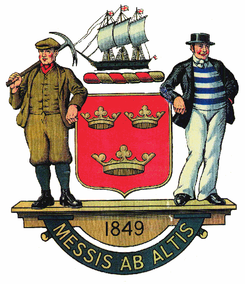
Tynemouth’s Three Kings (NZ374695)


Above is the coat of arms adopted by the Borough of Tynemouth upon its formation in 1849. The various bits and pieces are all pretty self-explanatory (the motto means something like ‘harvest of the deep’ – coal and fish, get it?). But what exactly do the three crowns mean?

Well, the shield which lies at the centre of the emblem was adopted due to its being that of the Prior of Tynemouth. And the story goes that the three crowns represent the three kings buried within the priory’s walls, namely Oswin, Osred and Malcolm.

The earliest of these, King Oswin, was the ruler of the ancient kingdom of Deira, that portion of Northumbria which lay between the Tees and the Humber. The northern bit, Bernicia, was at the time ruled by another individual. In 651, however, that other individual, one King Oswy, attacked the southern kingdom, sending Oswin first into retreat, then into surrender. Sending his troops home to save their lives, he then gave himself up to the enemy (or was betrayed – sources vary), was murdered by them, and interred at Tynemouth. He was later elevated to sainthood.

King Osred II became ruler of a united Northumbria in c.788-89, but soon fell himself in 790 to the previously deposed Aethelred. Fleeing into exile, he returned for another crack at the top job in 792, but was slain – probably by Aethelred’s men – before he’d had a chance to get himself organised. His murderers at least had the decency to have him buried at Tynemouth Priory.

King Malcolm III of Scotland died doing what he did best; raiding Northumbria. He was forever at it, and eventually paid with it with his life when he was defeated and slain at the Battle of Alnwick in 1093. His remains were interred at Tynemouth – though they were later reburied next to those of his wife, Margaret, at Dunfermline Abbey in the thirteenth century.

If you’d like to know more about the crest, see www.tynelives.org.uk/northsh/page2.htm  


Friday, 11 February 2011

Dial Cottage, West Moor (NZ274705)


Still standing on the Great Lime Road a little to the south of Killingworth, this splendid little relic of the past was home to George Stephenson and his young family during the early years of the nineteenth century. George was just starting out on his incredible career when he moved into the cottage – as a brakeman in charge of winding machinery at nearby West Moor Colliery – but was internationally famous by the time he relocated to Newcastle twenty years later.

When our man moved in, the cottage consisted of one room and a garret reached by a ladder. During his stay, though, he extended and converted the premises into a four-roomed house. The cottage has a sundial above the door, made by Stephenson himself, and an adjoining plaque which reads:-

George Stephenson. Engineer. Inventor of the Locomotive Engine. Lived in this cottage from 1805 to 1823; his first locomotive (Blücher) was built at the adjacent colliery wagon shops, and on July 25th 1814 was placed on the wagonway which crosses the road at the east end of this cottage.
George’s baby daughter and wife died during 1805-06, leaving George and his infant son as the only surviving family members. Dial Cottage therefore doubles its fame as the childhood home of the great Robert Stephenson…
 

Tuesday, 8 February 2011

Winslow Homer’s Cullercoats Period (NZ364715)


No one really knows why, but in the spring of 1881 eminent American painter, Winslow Homer, chose to spend eighteen months of his life in the Northumberland coastal village of Cullercoats. It was a period of his life which resulted in a widely acknowledged improvement in his artistic style and not a little fame for the fishing community itself.

The Bay Hotel, demolished as recently as 2005, was the great man’s home during his extended stay (then known as the Hudleston Arms Hotel). He maintained a studio across the road at No.12 Bank Top (demolished 1930), which enjoyed fine views out to sea and over the harbour.

Homer remained in the village until November 1882. A very private man, he was left in peace by the residents, who were no doubt used to his type, Cullercoats being something of a magnet for artists during 1870-1920 (other notables included Henry H.Emmerson, Robert Jobling, Arthur H.Marsh, Isa Thompson, John Falconer Slater and John Charlton). Homer was fascinated by the disappearing old ways of the fisherfolk, especially the fisherwives, who adorn many of his canvases. The images are sober, unfancy affairs, with an edgy realism – a style which was new to the artist, and which won him much admiration on his return to the States in late 1882: “He is a very different Homer from the one we knew in days gone by”; now his pictures “touch a far higher plane...They are works of High Art.”

An apartment block called Winlsow Court now stands on the site of the old Bay Hotel.

For a selection of Homer’s paintings of the village, see www.cullercoats.pwp.blueyonder.co.uk/org/homer.html ; and for general Cullercoats history see http://www.cullercoats.org.uk/ (and click on ‘history’- a good deal, too, on Homer here). More general biographical detail on the man can be found at http://en.wikipedia.org/wiki/Winslow_Homer ; and a splendid collection of his works is hosted at http://www.winslow-homer.com/ .


Friday, 4 February 2011

The Fat Ox (c.NZ355721)


This beauty was so famous in its day that the great engraver Thomas Bewick had an audience with it – if only to immortalise its image prior to the poor beast’s slaughter.

The famous eighteenth century quadruped – known variously as ‘The Fat Ox’, ‘The Whitley Large Ox’ or ‘The Whitley Great Ox’ – was the property of one Edward Hall, and was grazed up to its immense proportions upon fields now occupied by The Fat Ox pub in Whitley Bay. The engraving was produced for the owner, Mr Hall, and published on the 10th April 1789 – presumably to commemorate the animal’s demise.

The occasion of its death produced quite a stir, much as a public hanging might have, in fact. Truly a legend in its own lifetime, it was 5ft 9ins in height and an incredible 216 stone in its prime. It was so big and cumbersome – and presented such an awesome sight – that when it was due for slaughter it took seven days to walk it the ten miles or so to Newcastle through sizeable crowds.
 

Tuesday, 1 February 2011

John ‘Guinness’ Gilroy (c.NZ360720)


You may not have heard of him, but you will be familiar with his work.  For John Gilroy was the man behind the famous Guinness ads of the mid-twentieth century.  Still not sure?  Well, take a look at this lovely collage…

  
You all know him now, don’t you? And Gilroy, you’ll be pleased to learn, was a native of Whitley Bay.

Born into a large family in 1898, Gilroy followed his father William into the world of art. His dad was a marine landscape painter and technical draughtsman, and by the age of 15 young John was being paid for producing cartoons for the Newcastle Evening Chronicle. He went to school in Sandyford and Heaton (the family were by then living in the latter suburb) and ended up at Armstrong College Art School, Durham University.

He served in the Royal Field Artillery during World War I, and recommenced his studies at the Royal College of Art, London, in 1919. Prior to his graduation in 1923 he won many awards, prizes and scholarships, and went into teaching thereafter. He married his wife Gwendoline in 1924, with whom he was to have a son.

In 1925 he began his long-running association with Benson’s advertising agency. He worked on numerous commercial ventures (Bovril, Maclean's, Colman’s Mustard, etc) before his employers won the Guinness contract in 1928. Beginning with his first effort in 1930, he turned out more than 100 press advertisements and nearly 50 posters for the stout brewers over a 35-year period, the most famous being the ‘Guinness for Strength’ and ‘zookeeper and animals’ campaigns. From the 1940s he worked freelance.

Gilroy was also an accomplished painter of landscapes and portraits – including paintings of Churchill, the Royal family and the Pope. He exhibited regularly at the Royal Academy, and during World War II his work could often be seen via the Ministry of Information’s many campaigns. After his second marriage in 1950 he began an association with greetings card manufacturers, Royles.

He was appointed a Freeman of the City of London in 1981, and died in Guildford in 1985, aged 86.

If you’re eager for more, extended biographies can be found at
www.ncl.ac.uk/alumni/arches/page.htm?lovely-day-for-a-gilroy and
www.guinntiques.com/gilroy.aspx  


Friday, 28 January 2011

Name Changes and Funny Names (c.NZ360720)


The town now known as Whitley Bay seems as embedded in the popular culture of the North-East as any other place you care to name. It is as utterly distinctive to us locals for what it is and what is once was as anything else in the region’s rich history. And the splendidly named and beautifully formed landmark that is the Spanish City dome is unmistakable.

But the town’s name hasn’t always been as instantly recognisable. The name ‘Whitley’ goes way back, coming from the Old English wyt-leah, meaning ‘white meadow or pasture’; but it was for many centuries known simply as Whitley, and was a tiny place by today’s standards. In the Victorian era, however, it seems to have been known as Whitley-by-the-Sea, so as to distinguish it from Whitley Chapel and Whitley Castle in Northumberland. Then, in around 1902, the seldom used ‘by-the-Sea’ bit was dropped and replaced with ‘Bay’, allegedly to avoid confusion with Whitby in Yorkshire.

But wherever did the ‘Spanish City’ come from?

The answer is remarkably simple. In 1904, a merry band of entertainers known as the Toreadors Concert Party entertained visitors in an open-air theatre in Whitley Park. They had been brought there not from Spain, but from a few miles down the road by Mr Charles Elderton, who ran Hebburn’s Theatre Royal. For the occasion, the area was decorated in the Spanish style, and it became known as ‘the Spanish City’. It grew to be so popular that within a few years The Whitley Pleasure Gardens Company Ltd. was formed and a large fairground was established on the site. By 1910 the famous Dome was complete – in the Moorish style – and a legend was born.


Tuesday, 25 January 2011

The Backworth Treasure. Possibly. (c.NZ306722)


The Backworth Treasure, or Hoard, amounts to a collection of gold and silver objects found in 1812 – supposedly in a field near Backworth. As you can see, there’s a lovely silver pan, three spoons, a couple of brooches and several items of jewellery. There is also a single coin.

The hoard is something of a mystery. Not for what it is or represents – it is almost certainly an offering to the mother-goddesses, buried in the 1st or 2nd century AD – but rather for its somewhat circuitous route to its current home in the vaults of the British Museum. According to the esteemed British historian and archaeologist, Francis J Haverfield, who was at his academic peak around a century ago, the collection of goodies was first sold by its unknown discoverer to a Newcastle silversmith. They were then “all, or nearly all” resold to a Mr J Brumell, a Newcastle collector, from whom most of the objects passed, eventually, into the care of the British Museum in 1850.

No one seems to quite know where the reference to Backworth came from, nor is there any solid evidence as to its exact date of discovery. Furthermore, various descriptions of the find and its contents vary, suggesting that the treasure has been somewhat ‘diluted’ over the years as it passed between dealers. There is a clear suggestion that an 18inch-long silver dish has disappeared, and that there was not one, but in excess of 280 Roman denarii coins rattling around inside the silver pan. Inscriptions found on the goods leave us in little doubt that they were buried as a dedication to pagan deities.

Anyway, despite its cloudy history, we’re happy to claim the tidy little treasure as one of our own.


Friday, 21 January 2011

Battles and Moving Villages (NZ270720)


Camperdown is a settlement squeezed between the little village of Burradon to the north and Killingworth to the south, in the upper reaches of what is now Tyne & Wear. It does not loom especially large in the history books, but its presence on the modern-day map is the result of a curious and pretty much undocumented series of events.

The place didn’t even exist until the 1820s. But with the sinking of Burradon pit in 1820 and the construction of the Seaton Burn waggonway in 1826 a few buildings began to appear, and the small collection of streets came to be known as Hazlerigge, after the name of the local landowning family. However – and no one seems to know quite why – the inhabitants of the little place soon began referring to their new village as Camperdown, with the first reference appearing in the local parish register in 1840. The new label almost certainly came from the famous battle of the same name fought between the British and Dutch in 1797. Camperdown was an important and decisive victory during the Napoleonic wars, and was probably the biggest battle we’d ever won at sea at the time. It was not uncommon for places to be named after such important events, and interest in the Battle of Camperdown continued for many, many years after 1797.

As for the name Hazlerigge, well, this continued to be used somewhat loosely in the area; but by 1872, the Newcastle Weekly Chronicle reported that the old name was no longer being used by the residents and that they preferred to use Camperdown. And so it eventually became official.

Now you’re probably looking at your map and thinking, hold on a minute, I know fine well that Hazlerigg (no ‘e’) still exists, so what exactly are you talking about? Well, yes, the name did indeed live on – well, after a brief gap, anyway. In the 1890s, when a new coal pit was sunk a couple of miles to the west of Camperdown near Wideopen, the name Hazlerigg was adopted by the new settlement which subsequently developed around the pit-head.

So now you know. For much, much more on the history of Burradon and Camperdown see http://www.burradon-camperdown.co.uk/ .


Tuesday, 18 January 2011

The ‘Black Diamond’ of Seaton Burn (NZ238740)


Many of you will be familiar with William Irving’s famous painting of The Blaydon Races.  A quick search of the Internet soon brings the well-known canvas into view (see also links below).  In the middle distance on the right-hand side you will see a curious little character known as ‘The Black Diamond of Seaton Burn’.  Here he is:


The man in question was, supposedly, a black prize-fighter resident of the Northumberland village – some sources placing him in the eighteenth, others in the nineteenth, century. No amount of research seems to be able to pin this chap down, which has led many to suppose that he may be a fabrication of the artist’s imagination – like so many other of the characters depicted in the famous painting.

But “of Seaton Burn” is really quite specific, others say. Surely such a man must have existed? Maybe they’re right. But maybe he wasn’t black after all. As some of you may know, one of the most famous boxers of all time, Tom Cribb, was also known as ‘The Black Diamond’ on account of his routinely filthy appearance as a coal heaver at Wapping Docks at the turn of the nineteenth century. Now Cribb never lived in the North-East, but there would certainly have been plenty of other pitmen pugilists around at the same time, one or two of whom no doubt borrowed Cribb’s famous nickname.

The debate is an interesting one, and can be followed further here – with more on Irving’s painting here.


Friday, 14 January 2011

The Blackleg Miner (c.NZ287748)

 
One of the most infamous English folk songs of the 19th century, The Blackleg Miner is set in and around the Northumberland villages of Seaton Delaval and Seghill. An uncompromising statement aimed against mining strikebreakers, it has been revived and reused countless times over the years – most recently during the UK Miners’ Strike of 1984-85. It needs little more in the way of introduction, and nothing in the way of explanation…
 

The Blackleg Miner

It’s in the evenin’ after dark,
When the blackleg miner creeps ter wark,
In his moleskin pants and dirty short,
There goes the blackleg miner.

He taeks his pick and doon he goes,
To hew the coal that lies below,
There’s norra woman in this toon row,
Would look at the blackleg miner.

For Delaval is a terrible place,
They rub wet clay in the blackleg’s face,
Around the pits they run a foot race,
To catch the blackleg miner.

Divvn’t gan near the Seghill mine,
For across the top they’ve stretched a line,
To catch the throat and break the spine,
Of the dirty blackleg miner.

Well, they taek his pick and duds as well,
And they hurl them doon the Pit of Hell,
So off you go and fare thee well,
Yer dirty blackleg miner.

So join the union while you may,
And divvn’t wait till yer dying day,
For that may not be far away,
Yer dirty blackleg miner.


Tuesday, 11 January 2011

St.Mary’s Island & Lighthouse (NZ353755)


St.Mary’s Lighthouse has adorned the coast of Northumberland for over a century. Brilliant white against an azure sky, it presents one of the county’s finest summer sights.

The rocky, tidal outcrop 2½ miles north of Whitley Bay, known as St.Mary’s, or Bates, Island, has been home to a light of sorts for the past 400 years. It was not until 1898, however, that what may be called a proper lighthouse was erected. Its light burned for 86 years, being decommissioned by Trinity House in 1984. It was then bought jointly by the local council and others for the benefit of the community, and soon reopened as a tourist attraction.

The island is linked to the mainland by a concrete causeway which is covered at high tide, leaving the island itself separated from the shore by a short strait. The island has been extensively used over the years. It is thought to have been home to hermits prior to the construction of a chapel dedicated to St.Helen in the late eleventh century. Mention is made even at this early time of the maintenance of ‘a light’ in the tower. A burial ground existed next to the chapel for 700 years, but by 1860 all remains of the building had disappeared. The occasional mention of the name ‘Bates’ Island is a reference to one Thomas Bates, who owned the small patch of ground in the 1580s as Surveyor for Northumberland under Elizabeth I.

In ‘Smugglers’ Creek’ on the north of the island was found, in 1722, the body of Anthony Mitchell, a customs man – he was presumably killed by smugglers. A few years later, in 1739, Michael Curry, a local glassworker, was hanged in Newcastle for the murder of Robert Shevil, the landlord of the inn at Old Hartley – and his body was hung in shame from a gibbet at what became known as ‘Curry’s Point’, where the causeway meets the mainland. A plaque now marks the spot.

The island has seen a good deal of action over the years. Shipwrecks a plenty, for one thing; and in 1799 the island was used to isolate cholera-stricken Russian soldiers on their way to fight Napoleon. In 1855 George McEwan and family built the present-day cottage, and even opened a pub on the island. However, following a dispute with neighbouring landowners on the mainland, the McEwans were unceremoniously evicted in 1895.

Soon after this Trinity House decided to site a new lighthouse on the island and, nearly three years later, on 31st August 1898, the famous 137-step beacon was officially opened. Its lights ran on paraffin (kerosene) – and continued to do so until 1977 – the fuel being delivered every six months to the storage tanks under the tower. The oil lamp was replaced by an electric equivalent in the late 1970s, and the lighthouse became fully automated in 1979. Upon decommissioning in 1984 most of the lighthouse’s internal workings were removed. However, the building – and island as a whole – continues to serve the local community as an important tourist attraction. And you can still climb to the top!

The Lighthouse was given a facelift during 2008, and now looks better than ever.


P.S. To learn more about the island – and for some nice pics – see here.


Note: This article, and many others besides, can be found in the author’s collection of local history material here (and scroll down to Aspects of North-East History, Vol.1).


Friday, 7 January 2011

Seaton Sluice’s Sluice (NZ338768)


An unlikely name for a coastal village if ever there was one; but the little piece of engineering ingenuity which gave this settlement its name is worthy of investigation.

You see, before it ever had a sluice, Seaton Sluice, as a name, quite obviously didn’t exist. The area around the outflow of the Seaton Burn was known as, firstly, Hartley Pans, then Hartley Haven up until the mid- to late-1600s. The tiny little natural harbour shipped salt and coal, but was prone to silting – an issue which greatly hindered the port’s economic viability. The problem was solved by the local landowner, Sir Ralph Delaval, who hit upon the clever idea of constructing a pier with sluice gates that trapped the sea-water at high tide. By opening the gates at low tide, the water would rush out and cleanse the harbour. Everyone was so pleased with the new-fangled set-up that they re-christened the village Seaton Sluice. This all happened during 1660-90.

This worked with varying degrees of success for several decades; until, that is, the Delavals’ ambitions moved to a new level in the 1760s. Sir John and his brother, Thomas, decided that is was time to construct a new entrance for the village’s harbour, and set about cutting a new channel through solid rock to the east of the old entrance. A monumental task in its day, the new Cut, or ‘Gut’, measuring 52ft deep x 30ft wide x 900ft long, could be ‘sluiced off’ at both ends, thus allowing ship-loading to continue no matter what the state of the tide. Completed in 1764, the Seaton Sluice MkII proved to be a resounding success – in 1777, for instance, 177 ships carrying 48,000 tonnes of coal sailed from the harbour. The ingenious initiative also greatly helped the growth and prosperity of the local bottleworks – another Delaval family institution.

All of this is still very much in evidence today at Seaton Sluice – with many more historical remnants on view, besides. The area around the village and Seaton Delaval Hall is well worth a day’s outing, though a little historical research beforehand will help the visitor appreciate all there is on offer.
 

Tuesday, 4 January 2011

“Strange Tales” of Seaton Delaval Hall (NZ322766)


From The Monthly Chronicle of North Country Lore and Legend (December 1887):-
Strange tales used to be told by the old people of the neighbourhood of the mode of life of the Delavals in these extravagant days [late 18th century]. All the members of the family, male and female, were models of grace and beauty, the men perfect Adonises, the women worthy to contest the palm with the Cyprian goddess herself. They lived for luxurious enjoyment, love, and gallantry, the gayest of the gay, the wildest of the wild. Lord Delaval entertained an almost perpetual crowd of company at Delaval Hall. The frequent fêtes and masquerades that were given converted the house and gardens into a perfect fairyland, with throngs of gay and lively creatures frolicking and flirting about, as in the fabled isle of Calypso. The most extraordinary pranks used also to be played, to the amusement of all but the actual sufferers. The house was fitted up with strange contrivances for performing practical jokes. Beds were suspended, for instance, by pulleys over trap-doors, so that when the guests had retired after a carouse, and were just dropping asleep, they were rapidly let down into a cold bath! Another contrivance was that of partitions between sleeping rooms, which could be suddenly hoisted up into the ceiling, so that when ladies and gentlemen were retiring to rest, and had doffed all their finery, and were in various stages of undress, they were astonished to see the walls of the rooms disappear in a moment, as if by enchantment, the guests finding themselves in a miscellaneous assembly of both sexes in the oddest and most embarrassing plight imaginable.


Friday, 31 December 2010

Seaton Delaval Hall’s Extra Bits (c.NZ325765)


Seaton Delaval Hall, recently saved for the nation by a high profile campaign by the National Trust and a tenacious gang of enthusiastic locals, lies in a landscape full of interest to the amateur historian. However, rather than the old hall itself (whose history is interesting enough), it is to the pile’s lesser known outlying landmarks that I shall be turning to in this short article.

Perhaps the most conspicuous of the estate’s secondary constructions is the 18m-high stone obelisk 900m south-by-south-west of the hall. This was erected to the memory of Admiral George Delaval, the man who was responsible (with a little help from architect Sir John Vanbrugh) for the construction of the mighty edifice itself. The Admiral had bought the estate in 1718 from his debt-ridden kinsman, and was in the process of building the hall when he was tragically killed in spectacular fashion in 1723. When out riding in the fields he was unseated, caught his foot in a stirrup, and was dragged several hundred yards across the countryside before coming to a lifeless rest where the monument now stands. A second, now ruinous, obelisk lies just off the north side of the A190 a little to the west of the hall, marking the spot where the Admiral was originally unseated.

He wasn’t the last of his family to die an unusual death. Half a century later, a certain John Delaval, the then heir to the estate, died in 1775, aged 20, “as a result of having been kicked in a vital organ by a laundry maid to whom he was paying his addresses.” His father was so distraught, that he built a grand mausoleum in his honour half a mile east of the hall. The building is now ruinous.

© Copyright Michael Batey and licensed for reuse under this Creative Commons Licence. 


Tuesday, 28 December 2010

New Hartley Pit Disaster (NZ308768)


On 16th January 1862 one of the worst mining accidents in British history befell the workforce of New Hartley Colliery, a little to the north of Seaton Delaval in the South-East Northumberland Coalfield. A total of 204 men and boys – from age 10 to 70 – lost their lives underground when they became trapped and suffocated before help arrived. The catastrophe was to lead to a notable change in the industry’s working practice across the globe.

At the time of the accident the mine was served by a single shaft, as was the norm. This sole point of access took the miners to and from the coalface, and was the means by which both materials and air entered and exited the bowels of the earth. The mighty pumping beam cast its great shadow over the shaft head – as it did countless collieries the world over – its job being to clear the pit of flood water. And on that fateful winter morning its brittle cast-iron form snapped under the strain, sending 20 tons of metal thundering down the 12ft-square shaft, taking all with it. The beam, it is believed, had suffered a fatal fracture a week beforehand when it was rather heavy-handedly reassembled after its bearings had been replaced.

The debris which blocked the miners’ only means of escape proved impenetrable to the desperate rescuers over the coming days; the sounds of the entombed men and boys below a constant torment. After repeated collapses, the cause was lost – the trapped workers eventually falling silent. A little over a week later their bodies were finally recovered, many in quiet and peaceful repose, as if sleeping after a day’s hard work – brothers arm in arm, and fathers and sons in touching embrace.

Some good came of it, though. Such was the national public outcry that it was decreed that henceforth all mines should have two separate means of access and escape. Furthermore, the incident led to the establishment of the Miners Permanent Relief Fund – a fund that has since conferred benefit upon thousands in the mining community, including widows, orphans, injured workman and the aged.

The monument (pictured) stands in St. Alban's churchyard in Earsdon.

Read more here and here.


Friday, 24 December 2010

Tommy Thompson (NZ275783)


Thomas W.Thompson was born to become a miner, or so it seemed. A native of Shankhouse, Cramlington, that’s just what he became, in fact, like countless others of his generation, born, as he was, in 1884. But he dreamed of better things. Learning that a family friend had emigrated to America in the late 1800s, he set his dream into motion and decided to do likewise. So in 1910 he set sail.

He must have had some drive, though, for by the early 1920s he was the owner of a coal mine in East Peoria, Illinois, called the Manhattan Coal Co. In 1926, he married Hazel Appleby, who was 17 years Tommy’s junior. It seems that in Hazel’s father, John, Tommy had found a useful ally in his rise to the top.

His business was a strong one, and he was able to ride the Great Depression, it seems, with some ease. Such was his standing, that he was even able to co-found the First National Bank in East Peoria in 1934. Additionally, he became a director of a major savings & loan company, and ran a real estate business, the Manhattan Realty Co. – all of which helped him keep going after his coal company ceased operating in around 1940.

There is no doubt that Tommy was a major figure in the business life of his town. However, he and Hazel had no children, and she committed suicide in 1951, aged only 50. Tommy himself passed away in August 1965, aged 81, and was buried next to his wife – a very, very long way away from the Great Northern coalface of his youth, and a self-made man if ever there was one.

The great working class hero even has his own Facebook page here!


Tuesday, 21 December 2010

Cramlington’s Airships (NZ254782)


In its pre-‘New Town’ days, Cramlington was a good deal smaller than it is today. It was essentially rural for centuries; and even after the first coal pit was sunk there in the 1820s it remained modest in size.

However, in 1916, the town was selected as the site for the establishment of the ‘No.36 Home Defence Squadron’, with the protection of the coast south from Cramlington all the way down to Whitby coming under its remit. There was already a small base on the site, so the move was more of an ‘upgrade’, and it did its bit during the Great War by bringing down a zeppelin over Hartlepool in November 1916. When the airships were withdrawn from the skies, the base reverted to a training camp and the squadron was disbanded in 1919. Though the outfit has been reformed and disbanded several times since, its base was never again to be sited at Cramlington.

But the town is perhaps more famously remembered in aviation history as the home of a British airship landing ground and shed, from the latter stages of WWI to the 1930s. At a time when Britain was looking for ways to provide additional aerial scouting cover over the North Sea at the height of WWI, a site near Nelson Village to the NW of Cramlington was selected as a landing/technical site for our ‘Submarine Scout’ airships. However, the facility was not completed in time to be of any use during hostilities, with the war coming to an end before the base was finished.

The site was still completed, though, and some post-war activity did take place. But the complex was eventually taken over by a private company, who themselves constructed a modest airship which did some aerial photography and advertising during 1929-30 – before being lost in a storm over Belgium.

And that seems to have been that, with the giant airship shed surviving until the 1960s when it was demolished as part of Cramlington’s ‘New Town’ development.

See here for further information and some pics.